This week we see how satellite data can be used for storytelling, and we learn some ways that data reporting can improve breaking-news coverage.
PART 1: Storytelling with satellite images
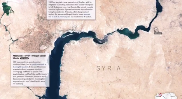
The New York Times often incorporates satellite imagery into graphic presentations to tell far-flung stories in new ways. Graphics editor Derek Watkins explains how he and his colleagues gather and use these publicly available images.
Reporting by Katy Mersmann.
[To skip directly to this segment in YouTube, click here.]
Examples:
- A Rogue State Along Two Rivers (ISIS progression along the Tigris and Euphrates)
- Assessing the Damage and Destruction in Gaza
Resources:
- NASA’s Landsat program has been continuously capturing images of the planet since the early 1970s, with most of the material available to use for free. The site includes a list of resources that explain how to access and use the imagery and data.
- The U.S. Geological Survey’s EarthExplorer “allows users to search, download, and order data held in USGS archives through a number of query options.”
- Planet Labs and SkyBox Imaging offer private satellite imagery data.
- Google Earth offers several ways to search and view imagery of the world, including historical iimages and ground-level, street-view visuals. An online tutorial explains how to make it work.
- For a more complete compilation of tools, resources, guidance and examples, check out this list from Knight-Mozilla fellow Brian Jacobs.
PART 2: Data for breaking news
Analyzing databases is often reserved for lengthy investigations, but some news organizations are benefiting from using big data to inform breaking-news coverage. We get some tips from Stephen Stock, senior investigative reporter at NBC Bay Area; and Cheryl Phillips, Hearst Professional in Residence and data journalism lecturer at Stanford University.
Reporting by Tatiana Darie.
[To skip directly to this segment in YouTube, click here.]
Resources useful during breaking news coverage:
- Investigative Reporters and Editors maintains a library of databases specifically for use by journalists. The data sets are free to IRE members but also can be purchased individually.
- Geofeedia.com is a free platform that allows users to locate pictures, videos and other multimedia elements around a particular location.
- OpenStatusSearch.com searches the Facebook public timeline without logging in. The site can be used to find victims, witnesses, neighbors, etc.
- Banjo is a smartphone app that allows users to explore live events and breaking news through a collection of real-time posts from people around the world.
- Capture offers publishers access to user material directly from social-media platforms and smartphone cameras.
Reuben Stern is the deputy director of the Futures Lab at the Reynolds Journalism Institute and host and co-producer of the weekly Futures Lab video update.
 The Reynolds Journalism Institute’s Futures Lab video update features a roundup of fresh ideas, techniques and developments to help spark innovation and change in newsrooms across all media platforms. Visit the RJI website for the full archive of Futures Lab videos, or download the iPad app to watch the show wherever you go. You can also sign up to receive email notification of each new episode.
